Posted On: Thursday - August 21st 2025 12:25PM MST
In Topics: Music Geography Race/Genetics
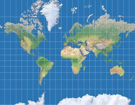
The World is a
Well, some Africans are all bent out of shape about th... oh, no pun intended there... they feel kind of marginalized, to put it in 21st Century terms. The Legal Insurrection site (Instapundit Glenn Reynolds links to them a lot) reports that these Africans' problem is the Mercator Projection. African Union Wants End to Mercator Projection Map Use Over “Disinformation”. The "disinformation" is Africa being displayed on maps using this projection as smaller than it is. The sub-headline:
The reason? African Union member unhappy with the relative size of the continent presented on those maps, as it makes them feel…marginalized.It's a mine is bigger than yours thing, but with continents. Why have White mapmakers been marginalizing Africa, hence, any Africans with chips on their shoulders (don't they all?) for well nigh 4 1/2 centuries? It's gotta be just pure hate.
It's not all maps though, but the Mercator Projection, as normally aligned, has this error of areas nearer the Poles displayed as larger than areas nearer the Equator.
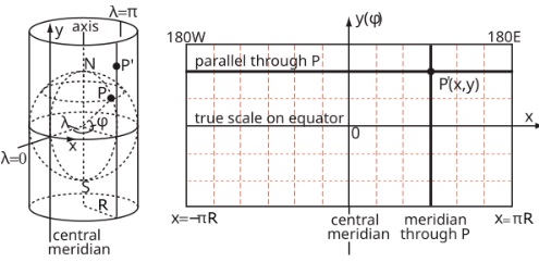
First of all, what IS a projection? See the figure above. To get that Wal-Mart globe paper onto a flat rectangular one must find a way to "project" the sphere's surface onto a rectangle that is positioned around it. One can think of this "projection" as using a light source to project every (almost) part of the map onto said surface and the tracing it out on the flat surface. Or, what you really do, after imagining this, is use math.
Math??? Yikes. I was led to believe there would be no Greek!
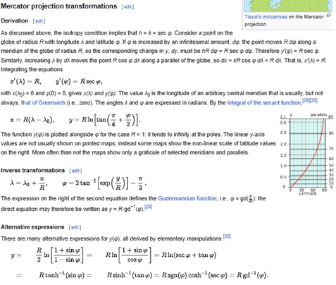
The diagram above from wiki shows the idea behind a Mercator projection It is one of multiple ways to transfer the surface-of-a-sphere picture of the world to a map sailors and, dare I say, World Conquerors and Colonizers could use. Why didn't they just carry globes? Kinda' hard to plot a course on one in the Captain's quarters ... In fact, as compared to other projections, the Mercator was deemed best for sailors keeping Rhumb Lines. These course that cross latitude lines at the same angle were easier to sail than other methods. They, BTW, are not Great Circle routes*, though for small distances, such as day-long drives it doesn't matter. In fact, the Flemish Geographer and Mapmaker Gerardus Mercator (see, he wasn't Greek, so...) who first presented his namesake projection in 1569, mentioned the difference:
Even for longer distances, the simplicity of the constant bearing makes it attractive. As observed by Mercator, on such a course the ship would not arrive by the shortest route but it will surely arrive.That's always the main thing. (This was well before Greta and the Climate Calamity™.)
Well, see, most people don't do a lot of sailing across the ocean these day, what with the long-range widebody airliners and all. Those who do sail have GPS and other than navigating the harbor and to the marina, probably couldn't even tell you on a globe where they really are. So, why use this Colonizer-made, Africa-marginalizing map projection now? (And let's not forget the Central Americans!)
Besides that we are used to this projection, that it preserves angles between lines/curves such as roads, makes a variant of the Mercator the best for the web mapping companies** and their amazing very usable software. Yet they bitch...:
Criticism of the Mercator map is not new, but the ‘Correct The Map’ campaign led by advocacy groups Africa No Filter and Speak Up Africa has revived the debate, urging organisations to adopt the 2018 Equal Earth projection, which tries to reflect countries’ true sizes.Sure, that explains the gap.
“The current size of the map of Africa is wrong,” Moky Makura, executive director of Africa No Filter, said. “It’s the world’s longest misinformation and disinformation campaign, and it just simply has to stop.”
Fara Ndiaye, co-founder of Speak Up Africa, said the Mercator affected Africans’ identity and pride, especially children who might encounter it early in school.
Yes, Africa is a huge continent. I remember learned how huge when reading the book From Cape to Cairo*** a couple of decades back. It's 6,000 miles from Cape Town, S. Africa to Cairo, Egypt!. I noted in our post on the old S. African Airways, 1st World Memories of Suid Afrikaanse Lugdiens (CtDC - Part 7) regarding a fuel stop in Kano, Nigeria:
... of the 5,600 statute mile shortest distance, Jo-burg to Palermo - the latter [segment] which could be considered entry to Europe on a direct route - is 1,130 miles, 4/5 of the whole route.Yet, with such a big continent to draw talent from, I don't think any Africans invented ANY map projections. I don't think they know how to make maps. What's to map there, anyway?
As the Chinaman said:
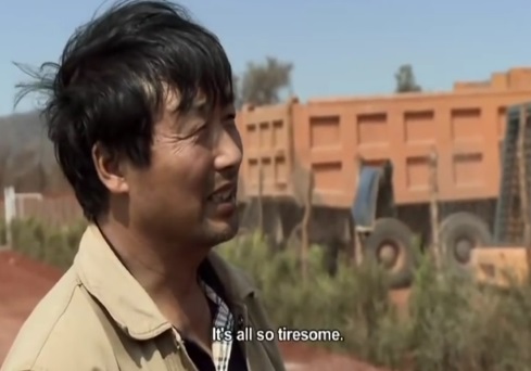
Oh, and who made the best music about Africa? A pale White lady out of some Celtic place named Enya did, that's who.
PS: I watched the entire Empire of Dust docu-frustration recently. We'll have a review of that one.
PPS: I've never watched The West Wing and likely never will. Commenter Adam Smith sent me to a web page about this map envy business and it had the following video from that show. If fits this post pretty well. Thanks, Adam!
* See Peak Stupidity's quick discussion of Great Circle routes, in Moslem call to prayer and the Great Circle route. Our follow up was titled Peak Stupidity is an Equal Opportunity Offender. One might see why we needed that 2nd part.
** We saw one of those google cars while driving home the other day, and it came right by our house as we were exiting the car. Unlike last time, I didn't have the time and wherewithal to flip off the camera. (I still have a blurry screenshot of me in front of my car flipping off the camera long ago.)
*** Were I to review it, I wouldn't give it too many kudos due to minor anti-Whiteness. Also, there is another From Cape to Cairo by some African author. Beyond that, there is also From THE Cape to Cairo, written about a trek over a century ago.
***********************************
[UPDATED 08/23:] Added West Wing video seen in page from Adam Smith link in comments here.
***********************************
Comments:
Moderator
Wednesday - August 27th 2025 12:22PM MST
PS: OK, Mr. Anderson, thanks for the info. I've been to Westover before, BTW, long ago... not in a C-5.
Ganderson
Monday - August 25th 2025 1:29PM MST
PS
C-5s are still around, Westover Air Force Base in Chicopee, Massachusetts is a center for them. They regularly fly very low over my house here in Collegetown. I actually think they do it just to piss off the liberals.
C-5s are still around, Westover Air Force Base in Chicopee, Massachusetts is a center for them. They regularly fly very low over my house here in Collegetown. I actually think they do it just to piss off the liberals.
Moderator
Monday - August 25th 2025 6:37AM MST
PS: Thanks, Adam, for the many related stories. As you might have seen, I put up the video from that 74million site article. Yes, I've seen that Sidney Sweeney pic with whatever logo - hard to read, haha. Was that faked? You cannot say easily anymore.
Mr. Anderson, using an orange was a great idea. Yes, there must be trade-offs. If everything was in perfect relation to the angles/lines/areas on a globe, then it's BE a globe.
What I should have written here too is, why doesn't Bill Gates or somebody donate a couple of squadrons of C-5's (they still flying) worth of Wal-Mart globes to Africa? How many 12" globes can fits in a C-5? I think we've been through this before here, haha.
Ganderson
Sunday - August 24th 2025 6:59AM MST
PS
Back when I wasn’t a parasite, I had a unit on maps- I used to begin it by drawing a map of the world on an orange (the big navel oranges work the best) , the peeling the orange to illustrate the difficulty in drawing a map of the world.
Of course converting a spherical surface to a flat surface involves trade-offs, typically shape for size. We in the modern world don’t do trade-off well though or at least we don’t generally recognize that they exist.
Adam Smith
Saturday - August 23rd 2025 8:30AM MST
PS: Doin' my part to get that comment count up there...
https://en.wikipedia.org/wiki/Winkel_tripel_projection
Cheers! ☮️
https://en.wikipedia.org/wiki/Winkel_tripel_projection
Cheers! ☮️
Adam Smith
Saturday - August 23rd 2025 8:24AM MST
PS: Life hack... Turn the map upside down for social justice!
https://i.ibb.co/wrcCwKgn/The-Organization-of-Cartographers-for-Social-Equality.jpg
☮️
https://i.ibb.co/wrcCwKgn/The-Organization-of-Cartographers-for-Social-Equality.jpg
☮️
Adam Smith
Saturday - August 23rd 2025 7:54AM MST
PS: Well, this is kinda fun...
https://thetruesize.com
☮️
https://thetruesize.com
☮️
Adam Smith
Saturday - August 23rd 2025 7:45AM MST
PS: Good morning, everyone!
https://www.the74million.org/article/boston-schools-have-vowed-to-combat-racist-maps-experts-want-a-better-geography-curriculum/
https://i.ibb.co/Vpv9QMT4/Cracker-Barrel.jpg
Happy Saturday! ☮️
https://www.the74million.org/article/boston-schools-have-vowed-to-combat-racist-maps-experts-want-a-better-geography-curriculum/
https://i.ibb.co/Vpv9QMT4/Cracker-Barrel.jpg
Happy Saturday! ☮️
Moderator
Saturday - August 23rd 2025 7:38AM MST
PS: Hello, Jay. Thanks for writing in. I just looked into the Cracker Barrel story. I do understand that eliminating the old White guy is typical wokeness, but otherwise the sign is just bland now. Is there anything else to the story I've missed? I do have a post in mind about this.
Haha, SafeNow, that was pretty good. As far as baristas go, I don't know how well this guy would fit in at the place near me. He'd probably better at least put a ring in his nose and tattoo half his face before the end of his probationary employment. "Sorry, you just don't fit in. Everyone else has been complaining that you look normal."
Haha, SafeNow, that was pretty good. As far as baristas go, I don't know how well this guy would fit in at the place near me. He'd probably better at least put a ring in his nose and tattoo half his face before the end of his probationary employment. "Sorry, you just don't fit in. Everyone else has been complaining that you look normal."
Moderator
Saturday - August 23rd 2025 7:34AM MST
PS: Hello, Jim (1234). I've never heard the use of Afro-Eurasian land mass. You're right about the geography. There's no use in distinguishing continents at all, if you're gonna describe things this way. (Europe v Asio was always tricky.) Now we'd be down to 4 if The Americas go together (with a canal too that makes the technically separated. Australia is just big island. Hell, Greenland is MUCH bigger and it's not a continent... but that's just my Mercator privilege speaking...
Is this a part of Globalism, erasing even Continental distinctions? I don't care if they do away with the Continental Breakfast. Just say, here's a bunch of carbs - have at it.
I pasted in that math from wiki, Jim, but to go over it, I'd have to get my mind right. It's been a while. ;-}
Is this a part of Globalism, erasing even Continental distinctions? I don't care if they do away with the Continental Breakfast. Just say, here's a bunch of carbs - have at it.
I pasted in that math from wiki, Jim, but to go over it, I'd have to get my mind right. It's been a while. ;-}
SafeNow
Friday - August 22nd 2025 5:50PM MST
PS
https://www.reddit.com/r/funny/comments/j5gxye/dont_trust_the_mercator_projection/#lightbox
The barista look. If the shoe fits…
https://www.reddit.com/r/funny/comments/j5gxye/dont_trust_the_mercator_projection/#lightbox
The barista look. If the shoe fits…
JAY
Friday - August 22nd 2025 2:31PM MST
PS . Map projection choice to up the dignity of Africans Maybe similar motivation to Cracker Barrel's decision this week.
People can't believe it that Cracker Barrel went woke. They're behind the times.
People can't believe it that Cracker Barrel went woke. They're behind the times.
J1234
Friday - August 22nd 2025 11:56AM MST
PS.
PS's interesting articles always inspire me to search out other online sources for further reading. In doing so with this article, I came across a phrase I wasn't familiar with: "the Afro-Eurasian landmass." I'd always heard of the Eurasian landmass, but when did they let Africa in? (The twentieth century, it seems. There went the neighborhood.) There's only a 120 mile wide strip of land connecting Africa with Asia (which is now divided by the Suez canal.)
African continental size fragility is just another manifestation of that all too common POC pathology: black narcissism. The few studies that discuss elevated levels of narcissism in "the community" seem to elicit the predictable response among offended blacks (a response that I actually agree with): blacks need their own unique psychological assessments and metrics. Normal assessments and metrics don't work with them.
Great article, but I admit that I kind of skipped over the math stuff. Sorry!
Moderator
Friday - August 22nd 2025 5:55AM MST
PS: Agreed, Alarmist. One wonders if the Western Euro nations would have even colonized the place had they not had the material resources they have. It may have worked out for the best, for everyone.
Hmm, that new archeological and biological evidence is something Steve Sailer would normally write about, if he hasn't already.
Hmm, that new archeological and biological evidence is something Steve Sailer would normally write about, if he hasn't already.
The Alarmist
Thursday - August 21st 2025 12:52PM MST
PS
What’s the point of being proud about having the largest landmass if one doesn’t know how to use it responsibly?
Seriously, the most resource-rich place in the world is also its biggest shithole, not because of the land, but because of the people who inhabit it.
BTW, increasing archeological and biological evidence refutes the OOA hypothesis, and it is driving the DEI academics crazy.
🕉